A Learnable Namibia - Advanced
67 metas · 201 locations · by Haldin
Agricultural Fields (Baity)
3
Agricultural Land
3
Ariamsvlei
3
Aus
3
Aussenkehr
3
Dry Mountains
3
Dry Rolling Hills
3
Flat and Dry Landscape
3
Gobabis
3
Henties Bay
3
Karibib
3
Lack Of Outer Yellows
3
Langstrand
3
Luderitz
3
Most Green Area
3
Noordoewer
3
NW to SE Small Ridges
3
Opuwo
3
Oranjemund
3
Otavi
3
Pink Sand Dunes
3
Road A1
3
Road B1 (Excellent Quality)
3
Road B1 (N Road Angle)
3
Road B1 (No Y Outlines)
3
Road B1 (NW Road Angle)
3
Road B1 (Rehoboth)
3
Road B1 (Southern Part)
3
Road B2 (E Road Angle)
3
Road B2 (NE Road Angle)
3
Road B2 (Sunrise Coverage)
3
Road B3
3
Road B4 (Bright Sandy Soil)
3
Road B4 (Railway)
3
Road B4 (Red Soil)
3
Road B4 (Seeman-Keetmanshoop Stretch)
3
Road B6
3
Road B8
3
Road C13
3
Road C14
3
Road C19
3
Road C22
3
Road C33
3
Road C34
3
Road C35 (Array Of Clouds)
3
Road C35 (Mt. Brandberg)
3
Road C35 (Red-tinted Pavement)
3
Road C35 (Sandy Landscape)
3
Road C38
3
Road C39
3
Road C40
3
Road C41
3
Road C43
3
Road C44
3
Road C47
3
Road C49
3
Road D3600
3
Rosh Pinah
3
Rundu
3
Sandy Landscape
3
Shrubbery Covered Mountains
3
Swakopmund/Walvis Bay
3
Tall and Lush Trees
3
Uis
3
Usakos
3
Vineyards
3
Windhoek
3
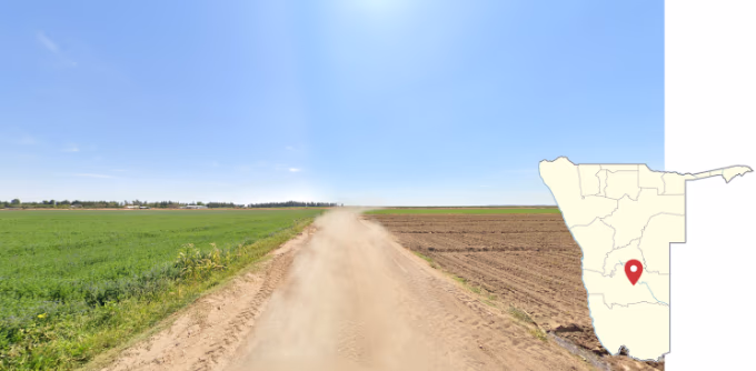
Agricultural Fields (Baity)
1 of 67 metas
These somewhat baity agricultural fields can be found just west of Mariental.
Description and images taken from: www.plonkit.net/namibia.
| Select all (67) | |
|---|---|
Agricultural Fields (Baity) 3 | |
Agricultural Land 3 | |
Ariamsvlei 3 | |
Aus 3 | |
Aussenkehr 3 | |
Dry Mountains 3 | |
Dry Rolling Hills 3 | |
Flat and Dry Landscape 3 | |
Gobabis 3 | |
Henties Bay 3 | |
Karibib 3 | |
Lack Of Outer Yellows 3 | |
Langstrand 3 | |
Luderitz 3 | |
Most Green Area 3 | |
Noordoewer 3 | |
NW to SE Small Ridges 3 | |
Opuwo 3 | |
Oranjemund 3 | |
Otavi 3 | |
Pink Sand Dunes 3 | |
Road A1 3 | |
Road B1 (Excellent Quality) 3 | |
Road B1 (N Road Angle) 3 | |
Road B1 (No Y Outlines) 3 | |
Road B1 (NW Road Angle) 3 | |
Road B1 (Rehoboth) 3 | |
Road B1 (Southern Part) 3 | |
Road B2 (E Road Angle) 3 | |
Road B2 (NE Road Angle) 3 | |
Road B2 (Sunrise Coverage) 3 | |
Road B3 3 | |
Road B4 (Bright Sandy Soil) 3 | |
Road B4 (Railway) 3 | |
Road B4 (Red Soil) 3 | |
Road B4 (Seeman-Keetmanshoop Stretch) 3 | |
Road B6 3 | |
Road B8 3 | |
Road C13 3 | |
Road C14 3 | |
Road C19 3 | |
Road C22 3 | |
Road C33 3 | |
Road C34 3 | |
Road C35 (Array Of Clouds) 3 | |
Road C35 (Mt. Brandberg) 3 | |
Road C35 (Red-tinted Pavement) 3 | |
Road C35 (Sandy Landscape) 3 | |
Road C38 3 | |
Road C39 3 | |
Road C40 3 | |
Road C41 3 | |
Road C43 3 | |
Road C44 3 | |
Road C47 3 | |
Road C49 3 | |
Road D3600 3 | |
Rosh Pinah 3 | |
Rundu 3 | |
Sandy Landscape 3 | |
Shrubbery Covered Mountains 3 | |
Swakopmund/Walvis Bay 3 | |
Tall and Lush Trees 3 | |
Uis 3 | |
Usakos 3 | |
Vineyards 3 | |
Windhoek 3 |
A Learnable Namibia - Advanced
Meta List · 67 metas · 201 locations · by Haldin
Agricultural Fields (Baity)
1 of 67 metas
These somewhat baity agricultural fields can be found just west of Mariental.
Description and images taken from: www.plonkit.net/namibia.